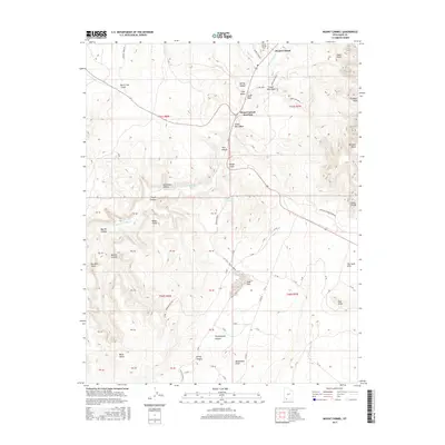
2017 Map of Mount Carmel
USGS Topo · Published 2017About this map
Mount Carmel and Mount Carmel Junction serve as the primary gateways to this dramatic high-desert landscape in Kane County. The terrain is defined by the E Fork Virgin River and its intricate drainage network, including Muddy Cr and several seasonally dry washes such as State Barn Wash. The mapping reveals striking geological formations, most notably the towering White Cliffs and Elkheart Cliffs that border the river valley. Local history is anchored at the Mount Carmel Cem and various named landmarks like Dianas Throne and Glendale Bench. This modern survey documents the intersection of human settlement and complex topography, tracing roads like Tait Ln and Mineral Spring Rd as they navigate around deep canyons like Yellowjacket Canyon and Joseph Canyon. The presence of Clay Flat and The Sand Hills illustrates the varied surface geology that characterizes this portion of the Colorado Plateau.
Find a feature on this map
45 named features on this map. Tap any name to fly to it.
Don’t see what you’re looking for? This feature index may not catch every label — zoom into the map to look around manually.
Map Details
Editions of this 2017 Mount Carmel Map
This is the sole edition of this map. No revisions or reprints were ever made.
Other maps of this area

1886 · Kanab
USGS Topo · 1:250,000

1953 · Cedar City
USGS Topo · 1:250,000

1954 · Kanab SW
USGS Topo · 1:24,000

1954 · Orderville Canyon SE
USGS Topo · 1:24,000

1954 · Kanab SE
USGS Topo · 1:24,000
1956 · Springdale SE
USGS Topo · 1:24,000

1956 · Springdale NE
USGS Topo · 1:24,000

1957 · Kanab
USGS Topo · 1:62,500

1958 · Cedar City
USGS Topo · 1:250,000

1958 · Orderville
USGS Topo · 1:62,500