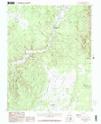
1985 Map of Mount Carmel
USGS Topo · Published 1985About this map
Mount Carmel and Mount Carmel Junction anchor the northern reaches of this mid-1980s landscape, situated where Muddy Creek joins the Virgin River drainage. The terrain is defined by dramatic geological transitions, notably the towering White Cliffs and Elkheart Cliffs that overlook a complex system of drainages including Miners Gulch and Yellowjacket Canyon. The map records a period of agricultural and infrastructural adaptation, showing a Gravel Pit and scattered Well sites amid the high-desert topography.
Find a feature on this map
35 named features on this map. Tap any name to fly to it.
Don’t see what you’re looking for? This feature index may not catch every label — zoom into the map to look around manually.
Map Details
Editions of this 1985 Mount Carmel Map
This is the sole edition of this map. No revisions or reprints were ever made.
Other maps of this area

1886 · Kanab
USGS Topo · 1:250,000

1953 · Cedar City
USGS Topo · 1:250,000

1954 · Kanab SW
USGS Topo · 1:24,000

1954 · Orderville Canyon SE
USGS Topo · 1:24,000

1954 · Kanab SE
USGS Topo · 1:24,000
1956 · Springdale SE
USGS Topo · 1:24,000

1956 · Springdale NE
USGS Topo · 1:24,000

1957 · Kanab
USGS Topo · 1:62,500

1958 · Cedar City
USGS Topo · 1:250,000

1958 · Orderville
USGS Topo · 1:62,500