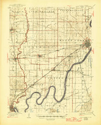
1904 Map of Mount Carmel
USGS Topo · Published 1946About this map
The Wabash River carves a winding course through this border region of Illinois and Indiana, defining the landscape before the era of modern river channelization. In the early twentieth century, the town of Mount Carmel serves as a significant rail hub, where the Southern R. R. and the St. Louis and Cairo Line intersect. The terrain is a mix of fertile lowlands like Lick Prairie and distinct elevations such as the Sugar Creek Hills and Foots Pond Hills. Smaller settlements and railroad stops, including Schrodts Sta., Keensburg, and Bellmont, are linked by a dense network of iron rails and wagon roads. To the south, the river forms dramatic loops near Crowleyville and Jimtown, while the Evansville Division of the railroad reaches into Grayville, highlighting the importance of steam transport to the local economy.
Find a feature on this map
49 named features on this map. Tap any name to fly to it.
Don’t see what you’re looking for? This feature index may not catch every label — zoom into the map to look around manually.
Map Details
Editions of this 1904 Mount Carmel Map
3 editions found
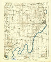
Other maps of this area

1901 · Princeton
USGS Topo · 1:62,500

1901 · Haubstadt
USGS Topo · 1:62,500

1903 · Haubstadt
USGS Topo · 1:62,500

1903 · New Harmony
USGS Topo · 1:62,500

1903 · Princeton
USGS Topo · 1:62,500

1903 · Patoka
USGS Topo · 1:125,000

1904 · Mount Carmel
USGS Topo · 1:62,500

1911 · Sumner
USGS Topo · 1:62,500

1913 · Sumner
USGS Topo · 1:62,500

1915 · Vincennes
USGS Topo · 1:62,500