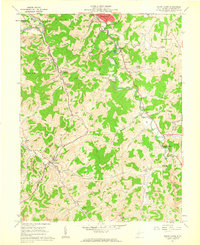
1961 Map of Mount Clare
USGS Topo · Published 1962About this map
Stonewood and the West Fork River valley dominate the northern reaches of this Harrison County survey, where the Baltimore and Ohio RR tracks wind through a landscape defined by industry and community. The presence of numerous strip mines and tipples reflects the region's mid-century reliance on coal production, particularly surrounding Mount Clare. Genealogists will find a high concentration of burial sites, from larger plots like Floral Hills Memorial Gardens (Cemetery) and Stonewall Park Cemetery to family landmarks like Haymond Cem and Nutter Cem. Local social life in the early 1960s is evidenced by the Clarksburg Country Club and the Drive-in Theater near Craigmoor. Further south, the map captures the quiet character of Lost Creek and the settlement at Rockford along Rockford Creek.
Find a feature on this map
63 named features on this map. Tap any name to fly to it.
Don’t see what you’re looking for? This feature index may not catch every label — zoom into the map to look around manually.
Map Details
Editions of this 1961 Mount Clare Map
3 editions found
Other maps of this area

1902 · Clarksburg
USGS Topo · 1:62,500

1902 · Fairmont
USGS Topo · 1:62,500

1904 · Philippi
USGS Topo · 1:62,500

1904 · Weston
USGS Topo · 1:62,500

1910 · Clarksburg
USGS Topo · 1:62,500

1923 · Fairmont
USGS Topo · 1:62,500

1923 · Clarksburg
USGS Topo · 1:62,500

1925 · Clarksburg
USGS Topo · 1:62,500

1925 · Philippi
USGS Topo · 1:62,500

1926 · Fairmont
USGS Topo · 1:62,500