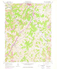
1961 Map of Mount Clare
USGS Topo · Published 1978About this map
Baltimore and Ohio railroad tracks follow the winding topography of Harrison County, connecting the industrial activities of Mount Clare and Lost Creek during the early 1960s. The landscape is heavily marked by the region's extraction history, with numerous Strip Mines and Strip Mine operations carved into the hillsides above West Fork River. This survey captures a rural Appalachian transition where established farming communities coexist with expanding industrial sites.
Find a feature on this map
59 named features on this map. Tap any name to fly to it.
Don’t see what you’re looking for? This feature index may not catch every label — zoom into the map to look around manually.
Map Details
Editions of this 1961 Mount Clare Map
3 editions found
Other maps of this area

1902 · Clarksburg
USGS Topo · 1:62,500

1902 · Fairmont
USGS Topo · 1:62,500

1904 · Philippi
USGS Topo · 1:62,500

1904 · Weston
USGS Topo · 1:62,500

1910 · Clarksburg
USGS Topo · 1:62,500

1923 · Fairmont
USGS Topo · 1:62,500

1923 · Clarksburg
USGS Topo · 1:62,500

1925 · Clarksburg
USGS Topo · 1:62,500

1925 · Philippi
USGS Topo · 1:62,500

1926 · Fairmont
USGS Topo · 1:62,500