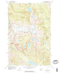
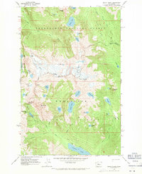
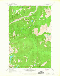
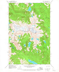
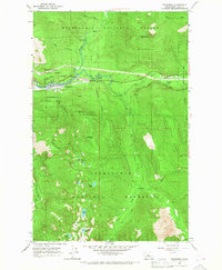
1965 Map of Mount Daniel
USGS Topo · Published 1971About this map
Mount Daniel and Mount Hinman dominate this high-alpine region along the boundary of Snoqualmie National Forest and Wenatchee National Forest. This 1965 field-checked survey reveals an intricate network of ice and water, featuring the Lynch Glacier and Hinman Glacier feeding into a dense concentration of high-elevation basins. The map documents numerous remote water bodies including Venus Lake, Jade Lake, and the large Waptus Lake at the southern edge.
Find a feature on this map
51 named features on this map. Tap any name to fly to it.
Don’t see what you’re looking for? This feature index may not catch every label — zoom into the map to look around manually.
Map Details
Editions of this 1965 Mount Daniel Map
3 editions found
Other maps of this area

1901 · Snoqualmie Pass
USGS Topo · 1:125,000

1902 · Skykomish
USGS Topo · 1:125,000

1903 · Snoqualmie
USGS Topo · 1:125,000

1905 · Skykomish
USGS Topo · 1:125,000

1957 · Wenatchee
USGS Topo · 1:250,000
1961 · Snoqualmie Pass
USGS Topo · 1:62,500
1961 · Kachess Lake
USGS Topo · 1:62,500
1965 · Stevens Pass
USGS Topo · 1:24,000
1965 · Mount Daniel
USGS Topo · 1:24,000
1965 · Skykomish
USGS Topo · 1:24,000