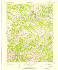
1954 Map of Mount Eden
USGS Topo · Published 1955About this map
The Mount Eden community serves as a central hub in this mid-century portrait of the Kentucky countryside, where the borders of Shelby, Spencer, and Anderson counties meet. The landscape is defined by the winding course of the Salt River and numerous feeder streams like Beech Creek and Tenmile Creek, which have carved deep valleys through the upland plateaus. This topography dictated a settlement pattern of ridge-top roads and clustered rural institutions. Small social centers are anchored by landmarks such as Salem Ch, Upper Brier Ridge Ch, and Bethlehem Ch, reflecting the deep-rooted importance of local congregations in these farming townships. Educational history is preserved through the locations of the Mount Eden Sch and the Walker Sch, while the names of Possum Ridge and Pea Ridge speak to the traditional agricultural character of the era before modern expansion.
Find a feature on this map
27 named features on this map. Tap any name to fly to it.
Don’t see what you’re looking for? This feature index may not catch every label — zoom into the map to look around manually.
Map Details
Editions of this 1954 Mount Eden Map
4 editions found
Other maps of this area

1923 · Waddy
USGS Topo · 1:48,000

1925 · Mount Eden
USGS Topo · 1:48,000

1927 · Mount Eden
USGS Topo · 1:62,500

1929 · Taylorsville
USGS Topo · 1:62,500

1952 · Ashbrook
USGS Topo · 1:24,000

1952 · Chaplin
USGS Topo · 1:24,000

1953 · Bloomfield
USGS Topo · 1:24,000
1954 · Glensboro
USGS Topo · 1:24,000

1954 · Taylorsville
USGS Topo · 1:24,000
1954 · Waddy
USGS Topo · 1:24,000