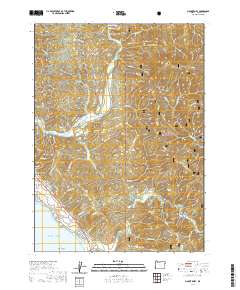
2020 Map of Mount Emily
USGS Topo · Published 2020About this map
Ostenbery Bar sits at a bend in the Chetco River, highlighting the intricate relationship between the coastal waterways and the steep terrain of Curry County. This landscape is defined by its dramatic ridges, including Panda Ridge and Gardner Ridge, which descend toward the shoreline where the Pacific Ocean meets landmarks like McVay Rock and Camel Rock. The survey preserves local history through the placement of the Pioneer Cem and Van Pelt Cem, located near the winding path of Tuttle Cr. To the east, the vast expanse of the Siskiyou National Forest dominates the interior, while the southern boundary follows the Winchuck River. The network of local roads such as Salmonberry Rd and N Bank Chetco River Rd reveals the patterns of modern rural access through this complex drainage system.
Find a feature on this map
87 named features on this map. Tap any name to fly to it.
Don’t see what you’re looking for? This feature index may not catch every label — zoom into the map to look around manually.
Map Details
Editions of this 2020 Mount Emily Map
This is the sole edition of this map. No revisions or reprints were ever made.
Other maps of this area

1929 · Crescent City
USGS Topo · 1:125,000

1945 · Point St. George
USGS Topo · 1:62,500

1949 · Eureka
USGS Topo · 1:250,000

1952 · Crescent City
USGS Topo · 1:62,500

1954 · Coos Bay
USGS Topo · 1:250,000

1954 · Cape Ferrelo
USGS Topo · 1:62,500

1954 · Mt. Emily
USGS Topo · 1:62,500

1956 · Smith River
USGS Topo · 1:24,000

1958 · Eureka
USGS Topo · 1:250,000

1958 · Coos Bay
USGS Topo · 1:250,000