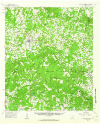
1960 Map of Mount Enterprise
USGS Topo · Published 1962About this map
Mount Enterprise serves as the central hub of this East Texas survey, situated at a significant highway junction where numerous family-named branches and bayous drain toward the Angelina River. The landscape is a dense network of rural communities, many identified by their central institutions such as Minden Elementary and High Sch or Old Prospect Ch. The southern portion of the map is defined by the Southern Pacific railroad corridor, which links the settlements of Trawick, Linn Flat, and Caro as it crosses Naconiche Creek. Extensive youth camps, including Camp Tonkawa and Whispering Pines, suggest the area's importance for regional recreation. Genealogists will find a wealth of data in the numerous family cemeteries like Helpenstell Cem and Isabell Chapel Cem, reflecting generations of settlement in Rusk and Nacogdoches counties.
Find a feature on this map
113 named features on this map. Tap any name to fly to it.
Don’t see what you’re looking for? This feature index may not catch every label — zoom into the map to look around manually.
Map Details
Editions of this 1960 Mount Enterprise Map
2 editions found

Other maps of this area

1935 · Henderson
USGS Topo · 1:48,000

1939 · Henderson
USGS Topo · 1:62,500

1943 · Cushing
USGS Topo · 1:62,500

1945 · Cushing
USGS Topo · 1:62,500

1952 · Douglass
USGS Topo · 1:62,500

1952 · Nacogdoches
USGS Topo · 1:62,500

1953 · Palestine
USGS Topo · 1:250,000

1956 · Tyler
USGS Topo · 1:250,000

1957 · Palestine
USGS Topo · 1:250,000

1958 · Martinsville
USGS Topo · 1:62,500