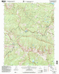
2004 Map of Mount Givens
USGS Topo · Published 2007About this map
Ansel Adams Wilderness and the John Muir Wilderness converge in this high-elevation landscape of the Sierra National Forest. The map documents a complex water management and recreational network, centered around the Lake Thomas A Edison spillway and the Portal Forebay Tunnel. High-altitude settlements and stopovers like Mono Hot Springs Resort, China Camp, and High Sierra are situated among a cluster of alpine lakes including Tule Lake, Corbett Lake, and Lakecamp Lake.
Find a feature on this map
68 named features on this map. Tap any name to fly to it.
Don’t see what you’re looking for? This feature index may not catch every label — zoom into the map to look around manually.
Map Details
Editions of this 2004 Mount Givens Map
2 editions found
Other maps of this area

1904 · Kaiser
USGS Topo · 1:125,000

1912 · Mt. Goddard
USGS Topo · 1:125,000

1947 · Mariposa
USGS Topo · 1:250,000

1948 · Mariposa
USGS Topo · 1:250,000

1953 · Mt Abbot
USGS Topo · 1:62,500

1953 · Huntington Lake
USGS Topo · 1:62,500

1953 · Blackcap Mtn
USGS Topo · 1:62,500

1953 · Kaiser Peak
USGS Topo · 1:62,500

1957 · Mariposa
USGS Topo · 1:250,000
1962 · Blackcap Mtn
USGS Topo · 1:62,500