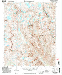
2004 Map of Mount Goddard
USGS Topo · Published 2007About this map
Goddard Divide serves as a high-altitude spine for this high Sierra landscape, separating the Evolution Basin from the Ionian Basin. This 2004 revision, based on surveys dating back to the 1970s, documents the dramatic topography of Kings Canyon National Park and the surrounding Sierra National Forest. The John Muir National Scenic Trail winds through the eastern portion of the map, descending through Le Conte Canyon past the Black Divide. Significant water features such as Wanda Lake, Helen Lake, and Martha Lake occupy the high basins, while the headwaters of the Kings River and Goddard Creek emerge from these glaciated slopes. Named peaks including Mount Goddard, Mount Solomons, and The Three Sirens anchor the interior ridges of the Sequoia-Kings Canyon Wilderness.
Find a feature on this map
49 named features on this map. Tap any name to fly to it.
Don’t see what you’re looking for? This feature index may not catch every label — zoom into the map to look around manually.
Map Details
Editions of this 2004 Mount Goddard Map
2 editions found
Other maps of this area

1903 · Tehipite
USGS Topo · 1:125,000

1905 · Tehipite
USGS Topo · 1:125,000

1912 · Mt. Goddard
USGS Topo · 1:125,000

1947 · Mariposa
USGS Topo · 1:250,000

1948 · Fresno
USGS Topo · 1:250,000

1948 · Mariposa
USGS Topo · 1:250,000

1948 · Mt. Goddard
USGS Topo · 1:62,500

1951 · Mt. Goddard
USGS Topo · 1:62,500

1952 · Mt. Goddard
USGS Topo · 1:62,500

1952 · Tehipite Dome
USGS Topo · 1:62,500