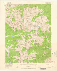
1955 Map of Mount Harvard
USGS Topo · Published 1960About this map
Mt Harvard and the surrounding Collegiate Peaks dominate this mid-century survey of the Continental Divide between Gunnison and San Isabel National Forests. In the north, the clearwater drainage of North Fork Clear Creek connects the mining-era settlements of Winfield and Vicksburg, while Tincup and Abbeyville sit in the southwestern quadrant. The map records several high-altitude extraction sites, such as the Silver King Mine near Missouri Basin and the Magdalene Mine in Magdalene Gulch. This era shows a landscape transitioning toward recreation, noted by the presence of the Collegiate Peaks Campground and Hughes Meadow Campground alongside older infrastructure like Halfway Station and Little Johns Cabin. Extensive trails, including the Frenchman Trail, weave through the drainage basins of Pine Creek and North Cottonwood Creek.
Find a feature on this map
124 named features on this map. Tap any name to fly to it.
Don’t see what you’re looking for? This feature index may not catch every label — zoom into the map to look around manually.
Map Details
Editions of this 1955 Mount Harvard Map
4 editions found

Other maps of this area

1889 · Leadville
USGS Topo · 1:125,000

1891 · Leadville
USGS Topo · 1:125,000

1909 · Mount Jackson
USGS Topo · 1:125,000

1911 · Mount Jackson
USGS Topo · 1:125,000

1934 · Taylor Park
USGS Topo · 1:62,500

1935 · Mount Elbert
USGS Topo · 1:62,500

1937 · Taylor Park
USGS Topo · 1:62,500

1938 · Mount Elbert
USGS Topo · 1:62,500

1939 · Mount Elbert
USGS Topo · 1:62,500

1940 · Garfield
USGS Topo · 1:62,500