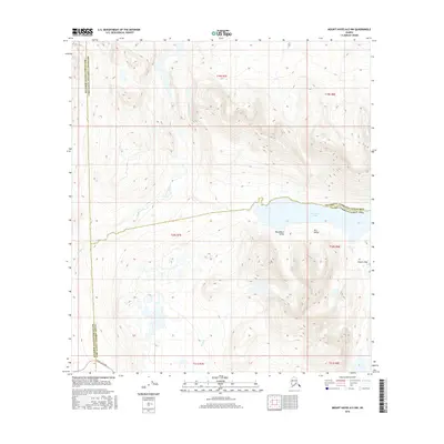
2016 Map of Mount Hayes A-5 NW
USGS Topo · Published 2016About this map
Denali Highway cuts through the southwestern corner of this landscape, providing a primary access point to a wilderness defined by its glacial and hydrological features. The terrain is marked by significant topographic landmarks including Glacier Gap and the distinctively named Houseblock Valley and Tarn Valley. These valleys and gaps suggest a complex geologic history shaped by ice movement, now occupied by high-altitude drainages. Hydrological patterns are dominated by Sevenmile Lake, which sits at a convergence of census area boundaries, and the headwaters of Boulder Creek and Rock Cr. The confluence of boundaries for the Matanuska-Susitna Borough, Southeast Fairbanks, and Valdez-Cordova census areas makes this a critical reference for understanding regional administrative limits in the Alaskan interior.
Find a feature on this map
17 named features on this map. Tap any name to fly to it.
Don’t see what you’re looking for? This feature index may not catch every label — zoom into the map to look around manually.
Map Details
Editions of this 2016 Mount Hayes A-5 NW Map
This is the sole edition of this map. No revisions or reprints were ever made.
Other maps of this area

1949 · Mount Hayes A-5
USGS Topo · 1:63,360

1950 · Mount Hayes
USGS Topo · 1:250,000

1950 · Mount Hayes A-6
USGS Topo · 1:63,360

1951 · Mount Hayes
USGS Topo · 1:250,000

1951 · Mount Hayes B-6
USGS Topo · 1:63,360

1951 · Mt. Hayes B-5
USGS Topo · 1:63,360

1952 · Mount Hayes A-6
USGS Topo · 1:63,360
1952 · Mount Hayes A-5
USGS Topo · 1:63,360

1955 · Mount Hayes
USGS Topo · 1:250,000
2016 · Mount Hayes A-5 NE
USGS Topo · 1:25,000