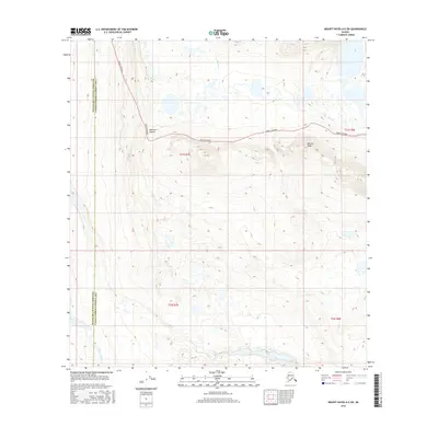
2016 Map of Mount Hayes A-5 SW
USGS Topo · Published 2016About this map
The Denali Highway winds across this high-elevation landscape, reaching its highest point at Maclaren Summit. This road corridor represents one of the primary infrastructure features in the region, connecting travelers through the drainage basins of the Alaska Range. The surrounding terrain is characterized by complex glacial topography, where small water bodies like Osar Lake and the headwaters of Rock Cr are dispersed among rolling hills and ridges. The map captures the meeting point of the Matanuska-Susitna Borough and the Valdez-Cordova Census Area, showing a vast expanse of undeveloped wilderness. Prominent landforms such as Whistle Ridge provide significant landmarks for navigation in an area defined by its seasonal wetlands and high alpine environment.
Find a feature on this map
10 named features on this map. Tap any name to fly to it.
Don’t see what you’re looking for? This feature index may not catch every label — zoom into the map to look around manually.
Map Details
Editions of this 2016 Mount Hayes A-5 SW Map
This is the sole edition of this map. No revisions or reprints were ever made.
Other maps of this area

1949 · Mount Hayes A-5
USGS Topo · 1:63,360

1950 · Mount Hayes
USGS Topo · 1:250,000

1950 · Mount Hayes A-6
USGS Topo · 1:63,360

1951 · Gulkana
USGS Topo · 1:250,000

1951 · Mount Hayes
USGS Topo · 1:250,000

1951 · Gulkana D-6
USGS Topo · 1:63,360

1951 · Gulkana D-5
USGS Topo · 1:63,360
1952 · Gulkana D-6
USGS Topo · 1:63,360
1952 · Gulkana D-5
USGS Topo · 1:63,360

1952 · Mount Hayes A-6
USGS Topo · 1:63,360