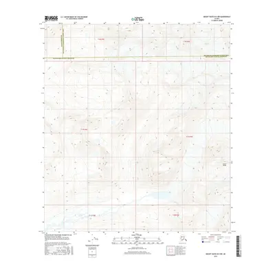
2016 Map of Mount Hayes B-6 NW
USGS Topo · Published 2016About this map
The Alaska Range dominates this terrain, where glacial movement and high-altitude water systems define the remote landscape. In the northern reaches of the map, the Susitna Glacier terminates among high ridges, feeding the intricate network of meltwater streams that eventually form the East Fork Susitna River. This waterway, also labeled as the E Fork Susitna River in its lower stretches, winds through a wide valley floor marked by seasonal braided channels. The map captures a high-altitude wilderness at a jurisdictional crossroads, showing where the boundaries of the Matanuska-Susitna Borough, the Denali Borough Southeast Fairbanks Census Area, and other regional divisions converge across the ridgelines. The land is largely defined by its natural contours and the absence of human infrastructure, representing the raw geography of the interior at the start of the 21st century.
Find a feature on this map
12 named features on this map. Tap any name to fly to it.
Don’t see what you’re looking for? This feature index may not catch every label — zoom into the map to look around manually.
Map Details
Editions of this 2016 Mount Hayes B-6 NW Map
This is the sole edition of this map. No revisions or reprints were ever made.
Other maps of this area

1950 · Mount Hayes
USGS Topo · 1:250,000

1950 · Healy B-1
USGS Topo · 1:63,360

1951 · Healy
USGS Topo · 1:250,000

1951 · Mount Hayes
USGS Topo · 1:250,000

1951 · Mount Hayes B-6
USGS Topo · 1:63,360

1951 · Healy C-1
USGS Topo · 1:63,360

1951 · Mount Hayes C-6
USGS Topo · 1:63,360

1952 · Healy B-1
USGS Topo · 1:63,360

1955 · Mount Hayes
USGS Topo · 1:250,000

1956 · Healy
USGS Topo · 1:250,000