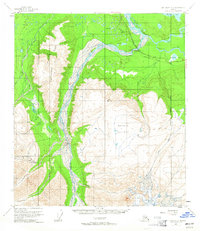
1955 Map of Mount Hayes C-2
USGS Topo · Published 1965About this map
The Alaska Highway cuts across the northern interior of this 1950s Alaskan landscape, serving as the primary corridor for transportation and communication. Infrastructure of the mid-century is prominently marked, including a Highway Maintenance Station and an Aboveground Pipeline running parallel to a Telephone Line near Johnson Slough. The terrain is defined by the braided channels of the Tanana River and the Johnson River, which drain the high elevations of Macomb Plateau and Independent Ridge. Local features like a Gravel Pit and several remote lakes, such as Craig Lake and Lisa Lake, suggest the logistical demands of maintaining routes through this subarctic environment. The presence of the Fairbanks Meridian and unsurveyed land lines highlight the era's ongoing effort by the Bureau of Land Management to formalize the geography of the Alaska Territory.
Find a feature on this map
23 named features on this map. Tap any name to fly to it.
Don’t see what you’re looking for? This feature index may not catch every label — zoom into the map to look around manually.
Map Details
Editions of this 1955 Mount Hayes C-2 Map
4 editions found
Other maps of this area

1950 · Mount Hayes
USGS Topo · 1:250,000

1951 · Mount Hayes
USGS Topo · 1:250,000

1954 · Mount Hayes B-1
USGS Topo · 1:63,360

1954 · Mount Hayes C-3
USGS Topo · 1:63,360

1954 · Mount Hayes D-2
USGS Topo · 1:63,360

1954 · Mount Hayes D-3
USGS Topo · 1:63,360

1954 · Mount Hayes D-1
USGS Topo · 1:63,360

1954 · Mount Hayes C-1
USGS Topo · 1:63,360

1955 · Mount Hayes B-3
USGS Topo · 1:63,360

1955 · Mount Hayes C-2
USGS Topo · 1:63,360