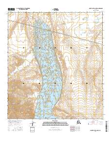
2016 Map of Mount Hayes C-5 NW
USGS Topo · Published 2016About this map
Trident Glacier dominates the central topography of this subarctic wilderness within the Alaska Range. This 2016 survey documents the massive ice field and its surrounding high-altitude drainage patterns, characterized by steep contour gradients and dramatic elevation changes. The land is strictly partitioned by the Public Land Survey System, with township and range lines like t14s r7e and t15s r7e providing the only human-imposed structure across this unpopulated glacial landscape. Researchers of glaciology and climate change will find the precise contour intervals valuable for observing the historical footprint of the ice and the resulting moraine patterns left in the wake of the glacial movement.
Find a feature on this map
11 named features on this map. Tap any name to fly to it.
Don’t see what you’re looking for? This feature index may not catch every label — zoom into the map to look around manually.
Map Details
Editions of this 2016 Mount Hayes C-5 NW Map
This is the sole edition of this map. No revisions or reprints were ever made.
Other maps of this area

1950 · Mount Hayes
USGS Topo · 1:250,000

1950 · Mount Hayes D-6
USGS Topo · 1:63,360

1950 · Mount Hayes D-5
USGS Topo · 1:63,360

1951 · Mount Hayes
USGS Topo · 1:250,000

1951 · Mount Hayes C-5
USGS Topo · 1:63,360

1951 · Mount Hayes C-6
USGS Topo · 1:63,360

1952 · Mount Hayes D-5
USGS Topo · 1:63,360
1952 · Mount Hayes D-6
USGS Topo · 1:63,360

1955 · Mount Hayes
USGS Topo · 1:250,000
2016 · Mount Hayes D-6 SE
USGS Topo · 1:25,000