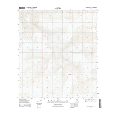
2016 Map of Mount Hayes C-6 SE
USGS Topo · Published 2016About this map
Mt Hayes and the high peaks of the Alaska Range dominate this 2016 survey, a landscape defined by massive ice fields and steep elevation changes. The quadrangle is characterized by a network of significant ice flows, including the Hayes Glacier in the north and the Trident Glacier and Susitna Glacier across the central section. To the south, the Black Rapids Glacier descends from the slopes of Aurora Peak. These features represent the dynamic glacial environment typical of this high-altitude region, where ice movement continues to shape the underlying terrain. Produced by the U.S. Geological Survey, the map provides an exacting look at the physical geography of this unpopulated stretch of the interior, recording the footprint of these glaciers at a specific moment in the early 21st century.
Find a feature on this map
11 named features on this map. Tap any name to fly to it.
Don’t see what you’re looking for? This feature index may not catch every label — zoom into the map to look around manually.
Map Details
Editions of this 2016 Mount Hayes C-6 SE Map
This is the sole edition of this map. No revisions or reprints were ever made.
Other maps of this area

1950 · Mount Hayes
USGS Topo · 1:250,000

1951 · Mount Hayes
USGS Topo · 1:250,000

1951 · Mount Hayes B-6
USGS Topo · 1:63,360

1951 · Mount Hayes C-5
USGS Topo · 1:63,360

1951 · Mt. Hayes B-5
USGS Topo · 1:63,360

1951 · Mount Hayes C-6
USGS Topo · 1:63,360

1955 · Mount Hayes
USGS Topo · 1:250,000
2016 · Mount Hayes B-6 NW
USGS Topo · 1:25,000
2016 · Mount Hayes C-5 NW
USGS Topo · 1:25,000
2016 · Mount Hayes C-6 NW
USGS Topo · 1:25,000