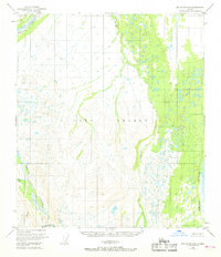
1950 Map of Mount Hayes D-5
USGS Topo · Published 1968About this map
Fort Greely occupies a significant portion of this interior landscape, illustrating the military footprint in the Alaskan territory during the mid-twentieth century. The terrain is defined by the braided courses of the Delta River and Delta Creek, which dominate the eastern and western margins of the map. These massive glacial drainages are fed by high-altitude sources such as the Triden Glacier in the southern reaches. The intricate network of wetlands and smaller tributaries like Hayes Creek and Ptarmigan Creek highlights the complex hydrology of the Tanana Valley region. This 1950 data, gathered via aerial photography, captures a landscape of extreme relief and shifting riverbeds before significant modern infrastructure developments altered the access to these remote reaches.
Find a feature on this map
8 named features on this map. Tap any name to fly to it.
Don’t see what you’re looking for? This feature index may not catch every label — zoom into the map to look around manually.
Map Details
Editions of this 1950 Mount Hayes D-5 Map
2 editions found
Other maps of this area

1949 · Big Delta A-6
USGS Topo · 1:63,360

1950 · Mount Hayes
USGS Topo · 1:250,000

1950 · Big Delta
USGS Topo · 1:250,000

1950 · Big Delta A-5
USGS Topo · 1:63,360

1950 · Mount Hayes D-4
USGS Topo · 1:63,360

1950 · Mount Hayes C-4
USGS Topo · 1:63,360

1950 · Big Delta A-4
USGS Topo · 1:63,360

1950 · Mount Hayes D-6
USGS Topo · 1:63,360

1950 · Mount Hayes D-5
USGS Topo · 1:63,360

1951 · Big Delta
USGS Topo · 1:250,000