
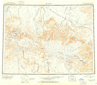
1951 Map of Mount Hayes
USGS Topo · Published 1951About this map
Glacial ice and high-altitude terrain dominate the Alaska Range in this mid-century reconnaissance, where the Delta River and Tanana River valleys dictate the path of human infrastructure. The survey highlights the essential role of highway stops in the interior, marking Rapids Roadhouse, Millers Roadhouse, and Moochigan Lodge along the Richardson Highway. These outposts, along with the settlement of Paxson near Summit Lake, represent the critical network supporting travel through Isabel Pass.
Find a feature on this map
53 named features on this map. Tap any name to fly to it.
Don’t see what you’re looking for? This feature index may not catch every label — zoom into the map to look around manually.
Map Details
Editions of this 1951 Mount Hayes Map
2 editions found
Other maps of this area

1948 · Tanacross A-6
USGS Topo · 1:63,360

1949 · Tanacross
USGS Topo · 1:250,000

1949 · Mount Hayes A-4
USGS Topo · 1:63,360

1949 · Gulkana D-3
USGS Topo · 1:63,360

1949 · Nabesna D-6
USGS Topo · 1:63,360

1949 · Big Delta A-6
USGS Topo · 1:63,360

1949 · Tanacross B-6
USGS Topo · 1:63,360

1949 · Fairbanks A-1
USGS Topo · 1:63,360

1949 · Healy A-1
USGS Topo · 1:63,360

1949 · Healy D-1
USGS Topo · 1:63,360