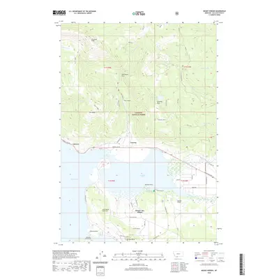
2020 Map of Mount Hebgen
USGS Topo · Published 2020About this map
Hebgen Lake dominates the southern half of this landscape, its waters reaching into the Grayling Arm and separated by the prominent Horse Butte Peninsula. The northern terrain rises sharply into the high country of the Gallatin National Forest, where features like Kirkwood Ridge and Mount Hebgen overlook the water. A geologically significant Red Canyon Fault is documented running through the mountains near Red Canyon Cr. Small lakeside communities and residential developments, including Lakeview, Grayling, and Hebgen Lake Estates, dot the shoreline. The intricate drainage network of Grayling Cr and Duck Creek feeds the lake from the east, while the western side is defined by the unique landforms of Edwards Peninsula and the constriction known as The Narrows.
Find a feature on this map
58 named features on this map. Tap any name to fly to it.
Don’t see what you’re looking for? This feature index may not catch every label — zoom into the map to look around manually.
Map Details
Editions of this 2020 Mount Hebgen Map
This is the sole edition of this map. No revisions or reprints were ever made.
Other maps of this area

1950 · Hebgen Dam
USGS Topo · 1:62,500

1955 · Ashton
USGS Topo · 1:250,000

1958 · Ashton
USGS Topo · 1:250,000

1958 · West Yellowstone
USGS Topo · 1:62,500
1958 · Tepee Creek
USGS Topo · 1:62,500

1960 · Ashton
USGS Topo · 1:250,000

1964 · Targhee Pass
USGS Topo · 1:24,000

1964 · Henrys Lake
USGS Topo · 1:62,500
1986 · Madison Arm
USGS Topo · 1:24,000
1986 · Richards Creek
USGS Topo · 1:24,000