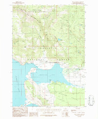
1986 Map of Mount Hebgen
USGS Topo · Published 1986About this map
Hebgen Lake dominates this mountain landscape, its waters filling the Grayling Arm and constricting at The Narrows. The complex shoreline includes the prominent Horse Butte Peninsula and Edwards Peninsula, framing the northern edge of the Madison Valley. To the north, the terrain rises sharply toward Mount Hebgen and Kirkwood Ridge, where the Cabin Creek Wildlife Management Area and Gallatin National Forest manage the high timberlands.
Find a feature on this map
28 named features on this map. Tap any name to fly to it.
Don’t see what you’re looking for? This feature index may not catch every label — zoom into the map to look around manually.
Map Details
Editions of this 1986 Mount Hebgen Map
This is the sole edition of this map. No revisions or reprints were ever made.
Other maps of this area

1950 · Hebgen Dam
USGS Topo · 1:62,500

1955 · Ashton
USGS Topo · 1:250,000

1958 · Ashton
USGS Topo · 1:250,000

1958 · West Yellowstone
USGS Topo · 1:62,500
1958 · Tepee Creek
USGS Topo · 1:62,500

1960 · Ashton
USGS Topo · 1:250,000

1964 · Targhee Pass
USGS Topo · 1:24,000

1964 · Henrys Lake
USGS Topo · 1:62,500
1986 · Madison Arm
USGS Topo · 1:24,000
1986 · Richards Creek
USGS Topo · 1:24,000