1964 Map of Mount Hermon
USGS Topo · Published 1971About this map
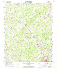
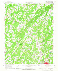
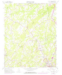
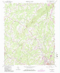
White Oak Mountain dominates the central landscape of this Pittsylvania County survey, creating a prominent ridge that separates the drainage of Pudding Creek and Sandy Creek. The cultural landscape is defined by small rural hubs and a network of country churches, including Gilfield Ch, Fleemon Ch, and Oak Grove Ch. In the south, the expansion of Danville is evident near New Design, where the city line meets the county at Highland Burial Park. Transport and industry are marked by the Southern Railway corridor through Blairs and Witt, while the presence of Laniers Mill and several schools like Mount Hermon Sch suggest the established social and economic centers of the mid-20th century. This edition includes 1970 photorevisions, highlighting the growth of residential structures and landmarks like the Tuscarora Country Club and the Radio Tower near the mountain peak.
Find a feature on this map
34 named features on this map. Tap any name to fly to it.
Don’t see what you’re looking for? This feature index may not catch every label — zoom into the map to look around manually.
Map Details
Editions of this 1964 Mount Hermon Map
4 editions found
Other maps of this area

1921 · Chatham
USGS Topo · 1:48,000

1922 · Callands
USGS Topo · 1:48,000

1923 · Danville
USGS Topo · 1:48,000

1923 · Chatham
USGS Topo · 1:62,500

1924 · Draper
USGS Topo · 1:48,000

1924 · Callands
USGS Topo · 1:62,500

1925 · Danville
USGS Topo · 1:62,500

1926 · Draper
USGS Topo · 1:62,500

1944 · Draper
USGS Topo · 1:62,500

1944 · Callands
USGS Topo · 1:62,500