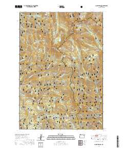
2020 Map of Mount Ireland
USGS Topo · Published 2020About this map
Mt Ireland and the surrounding Elkhorn Mountains define this high-elevation landscape within the Whitman National Forest. The map documents a topography dominated by steep ridgelines and glacial features, including Baldy Lake and the smaller Downie Lake. Seasonal access is highlighted by several winter routes such as the Elkhorn Drive Snowmobile trail, which winds through the northwestern corner near Granite Cr.
Find a feature on this map
56 named features on this map. Tap any name to fly to it.
Don’t see what you’re looking for? This feature index may not catch every label — zoom into the map to look around manually.
Map Details
Editions of this 2020 Mount Ireland Map
This is the sole edition of this map. No revisions or reprints were ever made.
Other maps of this area

1901 · Sumpter
USGS Topo · 1:125,000

1955 · Canyon City
USGS Topo · 1:250,000

1959 · Canyon City
USGS Topo · 1:250,000

1961 · Whitney
USGS Topo · 1:24,000

1972 · Trout Meadows
USGS Topo · 1:24,000

1972 · Mt. Ireland
USGS Topo · 1:24,000
1972 · Bourne
USGS Topo · 1:24,000
1972 · Granite
USGS Topo · 1:24,000
1972 · Sumpter
USGS Topo · 1:24,000

1972 · Greenhorn
USGS Topo · 1:24,000