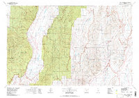
1978 Map of Mount Jefferson
USGS Topo · Published 1978About this map
Monitor Valley and the surrounding high desert of Nye County define this 1970s landscape, characterized by isolated mountain ranges and vast internal drainage basins. The settlement at Belmont stands as a focal point for local history, located near a Cemetery and several unnamed Mine and Prospect symbols that indicate the region's enduring mining interest. To the east, the map reveals the prominence of Mount Jefferson and the Table Mountain area within the Toiyabe National Forest.
Find a feature on this map
79 named features on this map. Tap any name to fly to it.
Don’t see what you’re looking for? This feature index may not catch every label — zoom into the map to look around manually.
Map Details
Editions of this 1978 Mount Jefferson Map
This is the sole edition of this map. No revisions or reprints were ever made.
Other maps of this area

1907 · Tonopah
USGS Topo · 1:250,000

1908 · Tonopah
USGS Topo · 1:250,000

1926 · Roberts Mountains
USGS Topo · 1:250,000

1929 · Roberts Mountains
USGS Topo · 1:250,000

1955 · Millett
USGS Topo · 1:250,000

1956 · Cockalorum Wash
USGS Topo · 1:62,500

1956 · Horse Heaven Mtn
USGS Topo · 1:62,500

1956 · Millett Ranch
USGS Topo · 1:62,500

1956 · Lund
USGS Topo · 1:250,000

1956 · Ely
USGS Topo · 1:250,000