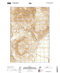
2019 Map of Mount Katmai A-4 NE
USGS Topo · Published 2019About this map
Trident Volcano dominates the northern reaches of this landscape, its volcanic peaks rising above the glacial and volcanic terrain of Katmai National Park. The land here is defined by high-altitude features like Observation Mtn and the deep drainage of the Katmai Valley to the southeast. The hydrology is dominated by the glacier-fed waters of the Katmai River and its various tributaries, including both Mageik Cr and Mageik Creek. The map also traces the jagged boundary between the Lake and Peninsula Borough and Kodiak Island Borough. This survey captures a region where geothermal activity and glacial runoff continuously reshape the land, with Martin Cr carving through the southern sections. It serves as a precise record of the volcanic topography within the Aleutian Range.
Find a feature on this map
15 named features on this map. Tap any name to fly to it.
Don’t see what you’re looking for? This feature index may not catch every label — zoom into the map to look around manually.
Map Details
Editions of this 2019 Mount Katmai A-4 NE Map
This is the sole edition of this map. No revisions or reprints were ever made.
Other maps of this area

1948 · Mt Katmai
USGS Topo · 1:250,000

1951 · Mt Katmai
USGS Topo · 1:250,000

1951 · Mount Katmai A-3
USGS Topo · 1:63,360

1951 · Mount Katmai B-4
USGS Topo · 1:63,360

1951 · Mount Katmai A-4
USGS Topo · 1:63,360

1951 · Mount Katmai B-3
USGS Topo · 1:63,360

1964 · Mt. Katmai
USGS Topo · 1:250,000
2019 · Mount Katmai A-4 NW
USGS Topo · 1:25,000
2019 · Mount Katmai A-4 SW
USGS Topo · 1:25,000
2019 · Mount Katmai A-4 SE
USGS Topo · 1:25,000