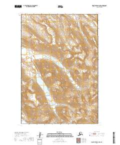
2019 Map of Mount Katmai B-3 NW
USGS Topo · Published 2019About this map
Katmai National Park encompasses the entirety of this landscape in the Lake and Peninsula Borough. The terrain is defined by high alpine ridges and steep glacial valleys, with numerous perennial snowfields or small glaciers clinging to the north-facing slopes of unnamed peaks. In the southwestern corner, Ikagluik Creek flows through a narrow valley, part of a complex hydrological system that drains this portion of the Aleutian Range. The absence of roads or permanent settlements highlights the wilderness character of the region, where the primary features are the raw geological forms and high-altitude drainage patterns recorded during this 2019 survey.
Find a feature on this map
8 named features on this map. Tap any name to fly to it.
Don’t see what you’re looking for? This feature index may not catch every label — zoom into the map to look around manually.
Map Details
Editions of this 2019 Mount Katmai B-3 NW Map
This is the sole edition of this map. No revisions or reprints were ever made.
Other maps of this area

1948 · Mt Katmai
USGS Topo · 1:250,000

1951 · Mt Katmai
USGS Topo · 1:250,000

1951 · Mount Katmai C-3
USGS Topo · 1:63,360

1951 · Mount Katmai B-4
USGS Topo · 1:63,360

1951 · Mount Katmai C-4
USGS Topo · 1:63,360

1951 · Mount Katmai B-3
USGS Topo · 1:63,360

1964 · Mt. Katmai
USGS Topo · 1:250,000
2019 · Mount Katmai B-3 SE
USGS Topo · 1:25,000
2019 · Mount Katmai B-3 NE
USGS Topo · 1:25,000
2019 · Mount Katmai B-4 NE
USGS Topo · 1:25,000