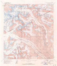
1954 Map of Mount McKinley A-1
USGS Topo · Published 1971About this map
Mt McKinley National Park and the interior of the Matanuska Susitna Borough are defined here by massive glacial systems and high-altitude peaks. Photogrammetric methods from 1954 captured the sprawling expanse of the Eldridge Glacier, which dominates the central valley, and the Muldrow Glacier in the northwest. The terrain rises sharply to named summits like Mount Mather and Mount Eldridge, documenting the ice-bound topography before later shifts in climate and nomenclature. This survey preserves the mid-century extent of these ice fields and the complex network of crevasses and lateral moraines that characterized this part of the Alaska Range.
Find a feature on this map
6 named features on this map. Tap any name to fly to it.
Don’t see what you’re looking for? This feature index may not catch every label — zoom into the map to look around manually.
Map Details
Editions of this 1954 Mount McKinley A-1 Map
3 editions found

Other maps of this area

1949 · Talkeetna Mountains D-6
USGS Topo · 1:63,360

1949 · Healy A-6
USGS Topo · 1:63,360

1950 · Talkeetna Mountains
USGS Topo · 1:250,000

1950 · Talkeetna
USGS Topo · 1:250,000

1951 · Talkeetna
USGS Topo · 1:250,000

1951 · Healy
USGS Topo · 1:250,000

1951 · Talkeetna Mountains D-6
USGS Topo · 1:63,360

1952 · Mount McKinley
USGS Topo · 1:250,000

1952 · Talkeetna Mountains D-6
USGS Topo · 1:63,360

1952 · Mount McKinley B-2
USGS Topo · 1:63,360