
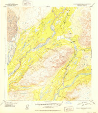
1952 Map of Talkeetna Mountains D-6
USGS Topo · Published 1952About this map
The Alaska Railroad defines the industrial corridor of this mid-century subarctic landscape, carving a path through the valley between the Susitna River and the high peaks of the Talkeetna range. Small rail-side settlements such as Hurricane, Chulitna, and Canyon mark essential stops along the line, while Gold Creek sits at the southern confluence of its namesake waterway. This 1949-era survey shows a region where travel beyond the rail depended on traditional means, evidenced by the Sled Road branching off near Salmon Creek. To the northwest, the massive Eldridge Glacier feeds into Partin Creek, illustrating the glacial origins of the braided Chulitna River. The map also identifies remote structures like the Cabin near Chulitna Pass and numerous survey monuments including VABM 4559 Indian, providing precise references for high-altitude landmarks in this wilderness area.
Find a feature on this map
27 named features on this map. Tap any name to fly to it.
Don’t see what you’re looking for? This feature index may not catch every label — zoom into the map to look around manually.
Map Details
Editions of this 1952 Talkeetna Mountains D-6 Map
2 editions found
Other maps of this area

1949 · Talkeetna Mountains D-6
USGS Topo · 1:63,360

1949 · Talkeetna Mountains C-6
USGS Topo · 1:63,360

1949 · Healy A-6
USGS Topo · 1:63,360

1950 · Talkeetna Mountains
USGS Topo · 1:250,000

1950 · Talkeetna
USGS Topo · 1:250,000

1950 · Talkeetna Mountains D-5
USGS Topo · 1:63,360

1950 · Healy A-5
USGS Topo · 1:63,360

1950 · Talkeetna Mountains C-5
USGS Topo · 1:63,360

1951 · Talkeetna
USGS Topo · 1:250,000

1951 · Healy
USGS Topo · 1:250,000