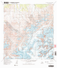
1954 Map of Mount McKinley A-3
USGS Topo · Published 1978About this map
Mt Mc Kinley National Park dominates this mid-century topographic study, which provides a detailed look at the massive ice and rock formations of the Alaska Range. Surveyed by the Museum of Science, Boston, and the Geological Survey, the map delineates the high-altitude topography surrounding Mount Mc Kinley, including the formidable Wickersham Wall and Churchill Peaks. The landscape is a network of massive ice flows, including the Straightaway Glacier, Foraker Glacier, and Kahiltna Glacier, which feed into the northern watersheds of Birch Creek and Slippery Creek. Small-scale human activity is sparsely represented, with a lone Mine noted near the northern boundary. Technical features such as the Tluna Icefall, Windy Corner, and Kahiltna Notch offer specific reference points for the mountaineering history of the era, while landmarks like Jeffery Dome and Mount Crosson define the perimeter of the Peters Basin.
Find a feature on this map
34 named features on this map. Tap any name to fly to it.
Don’t see what you’re looking for? This feature index may not catch every label — zoom into the map to look around manually.
Map Details
Editions of this 1954 Mount McKinley A-3 Map
4 editions found

Other maps of this area

1950 · Talkeetna
USGS Topo · 1:250,000

1951 · Talkeetna
USGS Topo · 1:250,000

1952 · Mount McKinley
USGS Topo · 1:250,000

1952 · Mount McKinley B-2
USGS Topo · 1:63,360

1953 · Mount McKinley B-4
USGS Topo · 1:63,360

1953 · Mount McKinley B-3
USGS Topo · 1:63,360

1953 · Mount McKinley A-4
USGS Topo · 1:63,360

1954 · Mount McKinley A-4
USGS Topo · 1:63,360

1954 · Mount McKinley B-3
USGS Topo · 1:63,360

1954 · Mount McKinley A-2
USGS Topo · 1:63,360