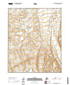
2018 Map of Mount Michelson D-5 SE
USGS Topo · Published 2018About this map
The Canning River defines the landscape of this Arctic quadrangle, carving through the Canning Valley in the northern reaches of the North Slope. This 2018 survey documents a remote wilderness environment where braided river channels and seasonal wetlands dominate the terrain. Unlike more settled regions, the map is defined by the absence of permanent human infrastructure, focusing instead on the complex hydrology and topography of the Alaskan interior. The mapping of t6n r22e and adjacent townships provides a technical baseline for this undeveloped corridor, where the natural shifts of the riverbed are the primary agents of change in the geography.
Find a feature on this map
6 named features on this map. Tap any name to fly to it.
Don’t see what you’re looking for? This feature index may not catch every label — zoom into the map to look around manually.
Map Details
Editions of this 2018 Mount Michelson D-5 SE Map
This is the sole edition of this map. No revisions or reprints were ever made.
Other maps of this area

1951 · Mt. Michelson
USGS Topo · 1:250,000

1955 · Mount Michelson C-5
USGS Topo · 1:63,360

1955 · Mount Michelson D-5
USGS Topo · 1:63,360

1955 · Mount Michelson C-4
USGS Topo · 1:63,360

1955 · Mount Michelson D-4
USGS Topo · 1:63,360

1956 · Mt. Michelson
USGS Topo · 1:250,000
1973 · Mount Michelson C-5
USGS Topo · 1:63,360

1978 · Mount Michelson C-4
USGS Topo · 1:63,360
2018 · Mount Michelson D-4 SW
USGS Topo · 1:25,000
2018 · Mount Michelson D-4 NW
USGS Topo · 1:25,000