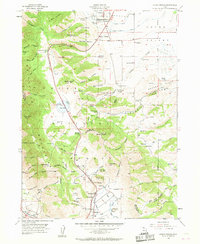
1955 Map of Mount Pisgah
USGS Topo · Published 1963About this map
Wellsville Mountains dominate the western horizon of this mid-century survey, creating a dramatic natural wall between Cache Valley and the lands to the west. The landscape is a study in early water management and high-altitude transport, anchored by the Lower Canal and Upper Canal that feed the agricultural settlements of Wellsville and Mendon. A notable transit corridor follows the path of Highways 89 and 91 through Sardine Canyon, climbing toward Sardine Summit past the seasonal waters of Dry Lake. This route connects the high peaks, including Mount Pisgah and Black Peak, with the valley floor. Genealogists and local historians can trace family ties through the Mount Sterling Cemetery or explore the drainage systems around Mantua, where the Box Elder Creek and a complex series of reservoirs illustrate the engineering required to sustain these mountain communities.
Find a feature on this map
95 named features on this map. Tap any name to fly to it.
Don’t see what you’re looking for? This feature index may not catch every label — zoom into the map to look around manually.
Map Details
Editions of this 1955 Mount Pisgah Map
4 editions found
Other maps of this area

1914 · Logan
USGS Topo · 1:125,000

1916 · Logan
USGS Topo · 1:125,000

1954 · Ogden
USGS Topo · 1:250,000

1954 · Brigham City
USGS Topo · 1:250,000

1955 · Paradise
USGS Topo · 1:24,000

1955 · Mantua
USGS Topo · 1:24,000

1955 · James Peak
USGS Topo · 1:24,000

1955 · Willard
USGS Topo · 1:24,000

1955 · Mount Pisgah
USGS Topo · 1:24,000

1955 · Brigham City
USGS Topo · 1:24,000