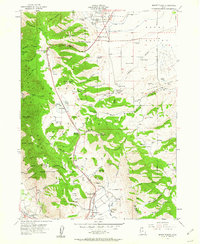
1955 Map of Mount Pisgah
USGS Topo · Published 1963About this map
Mount Pisgah dominates this mid-century survey of the divide between Cache and Box Elder counties. The landscape is defined by the steep transitions of the Cache National Forest, where high-altitude features like Black Peak and the Sardine Summit overlook a complex network of water management systems. Civil engineering is evident in the Upper Canal and Lower Canal servicing the northern valley near Wellsville, while an Aqueduct and multiple reservoirs trace the contours of the southern slopes near Mantua. Local life is anchored at the Mount Sterling Cemetery and the small settlement of Mount Sterling. The mapping of numerous springs, such as Leatham Springs and McBride Spring, along with named drainages like Silver Mine Hollow and Rattlesnake Canyon, highlights the critical importance of water resources in this mountainous Utah terrain.
Find a feature on this map
96 named features on this map. Tap any name to fly to it.
Don’t see what you’re looking for? This feature index may not catch every label — zoom into the map to look around manually.
Map Details
Editions of this 1955 Mount Pisgah Map
4 editions found
Other maps of this area

1914 · Logan
USGS Topo · 1:125,000

1916 · Logan
USGS Topo · 1:125,000

1954 · Ogden
USGS Topo · 1:250,000

1954 · Brigham City
USGS Topo · 1:250,000

1955 · Paradise
USGS Topo · 1:24,000

1955 · Mantua
USGS Topo · 1:24,000

1955 · James Peak
USGS Topo · 1:24,000

1955 · Willard
USGS Topo · 1:24,000

1955 · Mount Pisgah
USGS Topo · 1:24,000

1955 · Brigham City
USGS Topo · 1:24,000