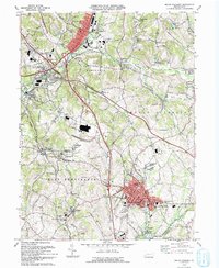
1993 Map of Mount Pleasant
USGS Topo · Published 1993About this map
Mount Pleasant serves as a major hub in this 1990s Westmoreland County landscape, where the dense settlement pattern of the borough contrasts with the scattered coal-patch towns and villages across Hempfield and East Huntingdon. Industrial legacy is etched into the terrain at Standard Shaft and Carpentertown, while the modern transportation corridor of the Pennsylvania Turnpike carves through the rolling hills near New Stanton. This era shows the region's evolution from a heavy mining and rail center toward a residential and transit-focused community.
Find a feature on this map
86 named features on this map. Tap any name to fly to it.
Don’t see what you’re looking for? This feature index may not catch every label — zoom into the map to look around manually.
Map Details
Editions of this 1993 Mount Pleasant Map
This is the sole edition of this map. No revisions or reprints were ever made.
Other maps of this area

1900 · Latrobe
USGS Topo · 1:62,500

1902 · Latrobe
USGS Topo · 1:62,500

1902 · Connellsville
USGS Topo · 1:62,500

1903 · Latrobe
USGS Topo · 1:62,500

1904 · Greensburg
USGS Topo · 1:62,500

1906 · Greensburg
USGS Topo · 1:62,500

1922 · Donegal
USGS Topo · 1:62,500

1931 · Connellsville
USGS Topo · 1:62,500

1935 · Donegal
USGS Topo · 1:62,500

1936 · Connellsville
USGS Topo · 1:62,500