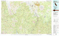
1979 Map of Mount Shasta
USGS Topo · Published 1979About this map
The massive volcanic peak of Mt Shasta and its surrounding Mt Shasta National Landmark dominate the northeastern portion of this territory, where the Southern Pacific railroad follows the winding corridor of the upper Sacramento River. In the late 1970s, the landscape was a complex mosaic of industrial timberlands, protected wilderness areas like the Salmon-Trinity Alps Primitive Area, and small communities built around the rail and river systems.
Find a feature on this map
93 named features on this map. Tap any name to fly to it.
Don’t see what you’re looking for? This feature index may not catch every label — zoom into the map to look around manually.
Map Details
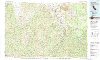
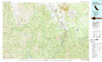
Editions of this 1979 Mount Shasta Map
3 editions found
Other maps of this area

1886 · Lassen Peak
USGS Topo · 1:250,000

1886 · Modoc Lava Bed
USGS Topo · 1:250,000

1886 · Shasta
USGS Topo · 1:250,000

1890 · Red Bluff
USGS Topo · 1:250,000

1892 · Modoc Lava-Bed
USGS Topo · 1:250,000

1892 · Lassen Peak
USGS Topo · 1:250,000

1894 · Lassen Peak
USGS Topo · 1:250,000

1894 · Red Bluff
USGS Topo · 1:250,000

1894 · Shasta
USGS Topo · 1:250,000

1901 · Redding
USGS Topo · 1:125,000