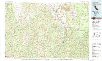
1979 Map of Mount Shasta
USGS Topo · Published 1992About this map
The massive cone of Mt Shasta and its satellite peak Shastina dominate the landscape, surrounded by the high-elevation forests of the Shasta National Forest and Klamath National Forest. At this time in the late 1970s, the region's industrial and recreational hubs are clearly defined along the Interstate 5 corridor and the timber-focused McCloud River RR. The survey highlights the intersection of transportation and terrain, with the Southern Pacific RR winding through the canyon of the Sacramento River past Shasta Springs and Dunsmuir. To the west, the remote Trinity Mountains and Salmon Mountains hide significant mining history, including the Bonanza King Mine and Altoona Mine near the headwaters of the Trinity River. This map captures the region before contemporary expansion, showing established settlements like Weed, Callahan, and McCloud amidst a landscape shaped by both volcanic activity and resource extraction.
Find a feature on this map
76 named features on this map. Tap any name to fly to it.
Don’t see what you’re looking for? This feature index may not catch every label — zoom into the map to look around manually.
Map Details
Editions of this 1979 Mount Shasta Map
3 editions found
Other maps of this area

1886 · Lassen Peak
USGS Topo · 1:250,000

1886 · Modoc Lava Bed
USGS Topo · 1:250,000

1886 · Shasta
USGS Topo · 1:250,000

1890 · Red Bluff
USGS Topo · 1:250,000

1892 · Modoc Lava-Bed
USGS Topo · 1:250,000

1892 · Lassen Peak
USGS Topo · 1:250,000

1894 · Lassen Peak
USGS Topo · 1:250,000

1894 · Red Bluff
USGS Topo · 1:250,000

1894 · Shasta
USGS Topo · 1:250,000

1901 · Redding
USGS Topo · 1:125,000