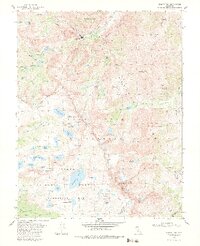
1982 Map of Mount Tom
USGS Topo · Published 1983About this map
Pine Creek Tungsten Mill sits at the industrial heart of this high-elevation landscape, flanked by the steep slopes of the Inyo National Forest and the John Muir Wilderness. The 1982 survey reveals a complex network of extractive industry high above the valley floor, including the Tungstar Mine and Hanging Valley Mine near the summit of Mount Tom. This area serves as a significant junction for mining history and alpine hydrology, where the headwaters of Morgan Creek and Pine Creek drain a glaciated basin.
Find a feature on this map
64 named features on this map. Tap any name to fly to it.
Don’t see what you’re looking for? This feature index may not catch every label — zoom into the map to look around manually.
Map Details
Editions of this 1982 Mount Tom Map
3 editions found
Other maps of this area

1912 · Mt. Goddard
USGS Topo · 1:125,000

1947 · Mariposa
USGS Topo · 1:250,000

1948 · Mariposa
USGS Topo · 1:250,000

1948 · Mt. Goddard
USGS Topo · 1:62,500

1949 · Mt. Tom
USGS Topo · 1:62,500

1951 · Mt. Tom
USGS Topo · 1:62,500

1951 · Mt. Goddard
USGS Topo · 1:62,500

1952 · Mt. Goddard
USGS Topo · 1:62,500

1953 · Mt Abbot
USGS Topo · 1:62,500

1953 · Blackcap Mtn
USGS Topo · 1:62,500