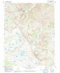
1982 Map of Mount Tom
USGS Topo · Published 1994About this map
Pine Creek Tungsten Mill and several high-altitude mining operations define the industrial character of this high Sierra landscape. Set within the overlapping boundaries of the John Muir Wilderness, Inyo National Forest, and Sierra National Forest, the map traces a complex network of extraction sites like the Tungstar Mine, Lambert Mine, and the Brownstone Mine. These operations were supported by specialized infrastructure, including a tramway and aqueduct, facilitating resource movement through difficult terrain near Four Gables and Mount Tom.
Find a feature on this map
75 named features on this map. Tap any name to fly to it.
Don’t see what you’re looking for? This feature index may not catch every label — zoom into the map to look around manually.
Map Details
Editions of this 1982 Mount Tom Map
3 editions found
Other maps of this area

1912 · Mt. Goddard
USGS Topo · 1:125,000

1947 · Mariposa
USGS Topo · 1:250,000

1948 · Mariposa
USGS Topo · 1:250,000

1948 · Mt. Goddard
USGS Topo · 1:62,500

1949 · Mt. Tom
USGS Topo · 1:62,500

1951 · Mt. Tom
USGS Topo · 1:62,500

1951 · Mt. Goddard
USGS Topo · 1:62,500

1952 · Mt. Goddard
USGS Topo · 1:62,500

1953 · Mt Abbot
USGS Topo · 1:62,500

1953 · Blackcap Mtn
USGS Topo · 1:62,500