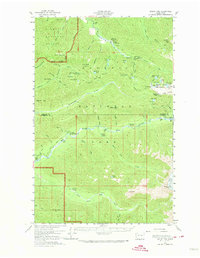
1956 Map of Mount Tom
USGS Topo · Published 1974About this map
Sol Duc Hot Springs and the Soleduck Ranger Sta anchor the northern landscape of this mid-century survey, which reveals a remote backcountry defined by the Hoh River and the Bogachiel River. The mapping captures the high-altitude character of the Seven Lakes Basin, where numerous alpine water bodies like Lunch Lake and Round Lake dot the High Divide. The interior is accessible only by a network of footpaths, such as Lovers Lane and various stretches of Trail, connecting a series of remote outposts including Mt Tom Shelter and Olympus Shelter. The southern reach is dominated by the massive White Glacier on the slopes of Mount Tom, illustrating the glaciated terrain before decades of significant glacial retreat. This survey serves as a vital record of the Olympic National Park wilderness infrastructure, showing the placement of the Hoh Ranger Station and several remote shelters used by early forest rangers and hikers.
Find a feature on this map
77 named features on this map. Tap any name to fly to it.
Don’t see what you’re looking for? This feature index may not catch every label — zoom into the map to look around manually.
Map Details
Editions of this 1956 Mount Tom Map

Other maps of this area

1918 · Lake Crescent
USGS Topo · 1:62,500

1919 · Port Crescent
USGS Topo · 1:62,500

1922 · Pysht
USGS Topo · 1:62,500

1922 · Lake Crescent
USGS Topo · 1:62,500

1935 · Mount Olympus
USGS Topo · 1:62,500

1939 · Mount Tom
USGS Topo · 1:62,500

1942 · Pysht
USGS Topo · 1:62,500

1942 · Mount Olympus
USGS Topo · 1:62,500

1943 · Spruce Mountain
USGS Topo · 1:62,500

1943 · Copalis Beach
USGS Topo · 1:250,000