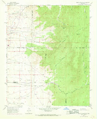
1954 Map of Mount Washington
USGS Topo · Published 1969About this map
Isleta Pueblo lands and the Sandia Military Reservation meet in this mid-century survey of the high desert terrain east of Albuquerque. The landscape is defined by the steep escarpments of Mount Washington and Sol se Mete Peak, within the boundaries of the Cibola National Forest. This era shows a transition in land use, marked by an Observation Cabin and the Marzano Lookout Tower (Aband) perched along the ridges. Below these heights, the intricate drainage system includes the deep incisions of Hell Canyon and the Arroyo del Coyote. The map provides specific locational detail for water sources critical to the region, such as Sol se Mete Spring and several designated Water Tanks, while delineating the complex overlapping of tribal, forest, and county boundaries between Bernalillo County and Valencia County.
Find a feature on this map
31 named features on this map. Tap any name to fly to it.
Don’t see what you’re looking for? This feature index may not catch every label — zoom into the map to look around manually.
Map Details
Editions of this 1954 Mount Washington Map
4 editions found

Other maps of this area

1888 · Bernalillo
USGS Topo · 1:125,000

1889 · Albuquerque
USGS Topo · 1:125,000

1892 · San Pedro
USGS Topo · 1:125,000

1893 · Albuquerque
USGS Topo · 1:125,000

1917 · Estancia
USGS Topo · 1:125,000

1934 · East Albuquerque
USGS Topo · 1:24,000

1938 · Albuquerque
USGS Topo · 1:62,500

1952 · Hubbell Spring
USGS Topo · 1:24,000

1952 · Los Lunas SE
USGS Topo · 1:24,000

1954 · Bosque Peak
USGS Topo · 1:24,000