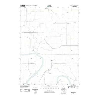
2010 Map of Mount Zion
USGS Topo · Published 2010About this map
The Des Moines River winds through the southern half of this Van Buren County landscape, creating a distinct physical boundary for the rural settlements of Mount Zion and Kilbourn. This area is characterized by a high density of small family and community burial grounds, such as Parkerville Cemetery and Winchester Cemetery, which speak to the deep genealogical roots of the region. The map reveals the layout of Birmingham in the north and the small crossroads of Winchester, connected by a grid of county roads and historic routes like Co Hwy J16. Waterways like Lick Creek and Chequest Creek cut through the farmland, defining the drainage patterns that have influenced agriculture and settlement since the area was first developed. The presence of the County Farm Cemetery indicates the site of former social services and public institutions central to the county's history.
Find a feature on this map
56 named features on this map. Tap any name to fly to it.
Don’t see what you’re looking for? This feature index may not catch every label — zoom into the map to look around manually.
Map Details
Editions of this 2010 Mount Zion Map
This is the sole edition of this map. No revisions or reprints were ever made.
Other maps of this area

1954 · Centerville
USGS Topo · 1:250,000

1957 · Centerville
USGS Topo · 1:250,000

1958 · Centerville
USGS Topo · 1:250,000

1958 · Burlington
USGS Topo · 1:250,000

1961 · Burlington
USGS Topo · 1:250,000

1963 · Burlington
USGS Topo · 1:250,000
1965 · Libertyville
USGS Topo · 1:24,000

1965 · Douds
USGS Topo · 1:24,000

1968 · Bonaparte
USGS Topo · 1:24,000

1968 · Keosauqua
USGS Topo · 1:24,000