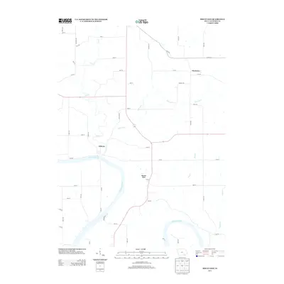
2013 Map of Mount Zion
USGS Topo · Published 2013About this map
The Des Moines River meanders through this portion of Van Buren County, anchoring the small rural settlements of Mount Zion and Kilbourn. This agricultural landscape is defined by the drainage patterns of numerous creeks, including Lick Cr, Little Lick Cr, and Little Cr, which cut through the terrain north of the river. The small community of Winchester sits in the northeast, connected by a network of local roads such as Co Hwy J16 and Lick Creek Rd. The map illustrates a contemporary rural Iowa layout where modern road designations like Osage Ave and Hawk Dr overlay a long-established pattern of river-valley settlement. This area remains primarily defined by its hydrology, with Rock Cr and Coppers Cr flowing toward the main river channel.
Find a feature on this map
48 named features on this map. Tap any name to fly to it.
Don’t see what you’re looking for? This feature index may not catch every label — zoom into the map to look around manually.
Map Details
Editions of this 2013 Mount Zion Map
This is the sole edition of this map. No revisions or reprints were ever made.
Other maps of this area

1954 · Centerville
USGS Topo · 1:250,000

1957 · Centerville
USGS Topo · 1:250,000

1958 · Centerville
USGS Topo · 1:250,000

1958 · Burlington
USGS Topo · 1:250,000

1961 · Burlington
USGS Topo · 1:250,000

1963 · Burlington
USGS Topo · 1:250,000
1965 · Libertyville
USGS Topo · 1:24,000

1965 · Douds
USGS Topo · 1:24,000

1968 · Bonaparte
USGS Topo · 1:24,000

1968 · Keosauqua
USGS Topo · 1:24,000