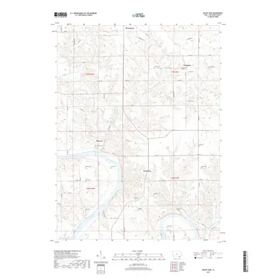
2018 Map of Mount Zion
USGS Topo · Published 2018About this map
The Des Moines River cuts through the southwest corner of this landscape, anchoring a rural Iowa territory defined by small settlements and numerous family and community burial grounds. Birmingham sits at the northern edge, while the hamlets of Winchester, Kilbourn, and Mount Zion are connected by a network of gravel and secondary roads. The map reveals a high density of genealogical sites, including the Winchester Cem and the uniquely named Railroad Grave located near the river's bend. This area of Van Buren County is characterized by the winding drainage of Lick Creek and Little Lick Cr, which carve through the farmland to reach the river. Notable institutional landmarks like the County Farm Cem offer evidence of early 20th-century social history and local land use patterns.
Find a feature on this map
69 named features on this map. Tap any name to fly to it.
Don’t see what you’re looking for? This feature index may not catch every label — zoom into the map to look around manually.
Map Details
Editions of this 2018 Mount Zion Map
This is the sole edition of this map. No revisions or reprints were ever made.
Other maps of this area

1954 · Centerville
USGS Topo · 1:250,000

1957 · Centerville
USGS Topo · 1:250,000

1958 · Centerville
USGS Topo · 1:250,000

1958 · Burlington
USGS Topo · 1:250,000

1961 · Burlington
USGS Topo · 1:250,000

1963 · Burlington
USGS Topo · 1:250,000
1965 · Libertyville
USGS Topo · 1:24,000

1965 · Douds
USGS Topo · 1:24,000

1968 · Bonaparte
USGS Topo · 1:24,000

1968 · Keosauqua
USGS Topo · 1:24,000