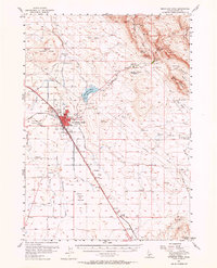
1956 Map of Mountain Home
USGS Topo · Published 1965About this map
Mountain Home serves as the central hub of this mid-century survey, revealing a landscape defined by the convergence of legacy migration routes and modern utility. The town center is densely detailed, featuring Elmore Memorial Hospital, the Drive-in Theatre, and two distinct burial grounds: Elmore Memorial Cemetery and Mtn View Cemetery. The infrastructure of the 1950s is on full display, from the Mountain Home Municipal Airport and a Microwave Relay Station to the industrial presence of the Oregon Short Line.
Find a feature on this map
39 named features on this map. Tap any name to fly to it.
Don’t see what you’re looking for? This feature index may not catch every label — zoom into the map to look around manually.
Map Details
Editions of this 1956 Mountain Home Map
2 editions found

Other maps of this area

1892 · Mountain Home
USGS Topo · 1:125,000

1892 · Camas Prairie
USGS Topo · 1:125,000

1893 · Mountain Home
USGS Topo · 1:125,000

1893 · Camas Prairie
USGS Topo · 1:125,000

1947 · Bruneau
USGS Topo · 1:62,500

1947 · Indian Cove
USGS Topo · 1:24,000

1947 · Hammett
USGS Topo · 1:24,000

1947 · Sand Dunes
USGS Topo · 1:24,000

1947 · Bruneau
USGS Topo · 1:24,000

1948 · Sand Dunes
USGS Topo · 1:24,000