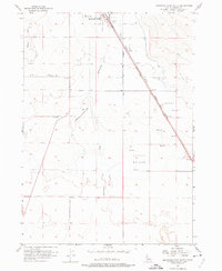
1956 Map of Mountain Home South
USGS Topo · Published 1974About this map
Mountain Home serves as the focal point for this mid-century look at the High Desert landscape, where early pioneer routes and modern transportation corridors intersect. The map illustrates a transition from the historic Old Freight Trail and the Old Mountain City-Mountain Home Trail to the developing infrastructure of the 1950s. The Short Line Highway (Oregon Trail) runs alongside the Union Pacific railroad, tracing a path through Slade Flat toward the southern outskirts of the settlement.
Find a feature on this map
17 named features on this map. Tap any name to fly to it.
Don’t see what you’re looking for? This feature index may not catch every label — zoom into the map to look around manually.
Map Details
Editions of this 1956 Mountain Home South Map
3 editions found
Other maps of this area

1892 · Mountain Home
USGS Topo · 1:125,000

1893 · Mountain Home
USGS Topo · 1:125,000

1947 · Bruneau
USGS Topo · 1:62,500

1947 · Indian Cove
USGS Topo · 1:24,000

1947 · Sand Dunes
USGS Topo · 1:24,000

1947 · Bruneau
USGS Topo · 1:24,000

1948 · Sand Dunes
USGS Topo · 1:24,000

1948 · Indian Cove
USGS Topo · 1:24,000
1948 · Bruneau
USGS Topo · 1:24,000

1948 · Indian Cove
USGS Topo · 1:62,500