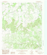
1984 Map of Mountain Pass
USGS Topo · Published 1984About this map
Mulberry Canyon dominates the upper half of this Taylor County landscape, a prominent geological feature in a region of high mesas and shifting elevations. The small settlement of Nubia sits near the head of this canyon, while further south, the namesake Mountain Pass and Bald Mountain define the divide between different drainage basins. This 1984 provisional map, based on field checks from the late 1970s, captures the rural character of the area as it transitioned through the late 20th century.
Find a feature on this map
15 named features on this map. Tap any name to fly to it.
Don’t see what you’re looking for? This feature index may not catch every label — zoom into the map to look around manually.
Map Details
Editions of this 1984 Mountain Pass Map
2 editions found
Other maps of this area

1890 · Abilene
USGS Topo · 1:125,000

1892 · Abilene
USGS Topo · 1:125,000

1893 · Sweetwater
USGS Topo · 1:125,000

1954 · Big Spring
USGS Topo · 1:250,000

1954 · Abilene
USGS Topo · 1:250,000

1957 · Merkel
USGS Topo · 1:62,500

1957 · Buffalo Gap
USGS Topo · 1:62,500

1958 · Big Spring
USGS Topo · 1:250,000

1958 · Abilene
USGS Topo · 1:250,000
1967 · Shep
USGS Topo · 1:24,000