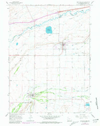
1964 Map of Mountain View
USGS Topo · Published 1981About this map
Blacks Fork meanders across the high plains of Uinta County, defining the agricultural and transit corridor that links Lyman, Urie, and Mountain View. This landscape preserves the deep history of westward expansion, clearly marking the path of the Emigrant Trail alongside modern infrastructure like Rollins Reservoir. The water management systems here are vital to the area's character, with the North Fork Smiths Creek and South Fork Smiths Creek feeding into the wider valley below Tipperary Bench. To the south, the aptly named Poverty Flats stretches toward the horizon, contrasting with the clustered activity of the town centers, where a local Cem, Fairground, and Radio Tower serve as the primary community landmarks in this sparsely settled region of southwestern Wyoming.
Find a feature on this map
30 named features on this map. Tap any name to fly to it.
Don’t see what you’re looking for? This feature index may not catch every label — zoom into the map to look around manually.
Map Details
Editions of this 1964 Mountain View Map
2 editions found
Other maps of this area

1954 · Ogden
USGS Topo · 1:250,000

1958 · Ogden
USGS Topo · 1:250,000

1960 · Ogden
USGS Topo · 1:250,000

1964 · Reed Reservoir
USGS Topo · 1:24,000

1964 · Fort Bridger
USGS Topo · 1:24,000

1964 · Carter
USGS Topo · 1:24,000

1964 · Mountain View
USGS Topo · 1:24,000

1964 · Austin Reservoir
USGS Topo · 1:24,000
1964 · Leavitt Bench
USGS Topo · 1:24,000
1964 · Robertson
USGS Topo · 1:24,000