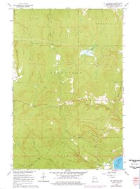
1964 Map of Mt. Ashwabay
USGS Topo · Published 1976About this map
Mt Ashwabay rises above the timbered landscape of the Bayfield Peninsula, overlooking the cold waters where the Onion River and Little Sioux River meet Lake Superior. This mid-1960s survey, updated in the mid-1970s, captures a transitional era of land use in the towns of Russell, Bayfield, and Bayview. The interior is defined by a dense network of watercourses including Sand River and Racket Creek, which drain the upland through various Gravel Pit sites toward the coast. Significant topographical features like Sultz Swamp illustrate the varied drainage patterns of this northern Wisconsin terrain. The map is particularly useful for tracking the network of secondary roads and field lines that carve through the woods, providing a detailed record of the rural infrastructure before modern developments changed the character of these lakeside townships.
Find a feature on this map
13 named features on this map. Tap any name to fly to it.
Don’t see what you’re looking for? This feature index may not catch every label — zoom into the map to look around manually.
Map Details
Editions of this 1964 Mt. Ashwabay Map
2 editions found
Other maps of this area

1941 · Bayfield
USGS Topo · 1:48,000

1942 · Ashland
USGS Topo · 1:48,000

1944 · Moquah
USGS Topo · 1:48,000

1944 · Cornucopia
USGS Topo · 1:48,000

1946 · Cornucopia
USGS Topo · 1:48,000

1946 · Bayfield
USGS Topo · 1:48,000

1947 · Moquah
USGS Topo · 1:48,000

1947 · Ashland
USGS Topo · 1:48,000

1953 · Ashland
USGS Topo · 1:250,000

1958 · Ashland
USGS Topo · 1:250,000