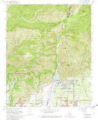
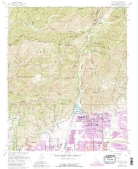
1967 Map of Mt. Baldy
USGS Topo · Published 1982About this map
Angeles National Forest and San Bernardino National Forest dominate this landscape, meeting along the steep drainage of San Antonio Canyon. The map reveals the critical infrastructure managing the transition from these steep heights to the residential developments of the valley floor, most notably the San Antonio Dam and its spillway. In the higher elevations, the settlement of Mt Baldy and the outlier at Barrett serve as nodes in the canyon network. Local cultural and educational history is anchored by the Padua Hills Theater and institutional sites like the Girls Collegiate Sch and Scudder Oaks Sch. The intricate system of fire roads and trails, such as the Glendora Ridge Road and the Sunset Ridge Fire Road, underscores the region's historical focus on fire management and forestry within the San Dimas Experimental Forest.
Find a feature on this map
75 named features on this map. Tap any name to fly to it.
Don’t see what you’re looking for? This feature index may not catch every label — zoom into the map to look around manually.
Map Details
Editions of this 1967 Mt. Baldy Map
5 editions found
Other maps of this area

1894 · Pomona
USGS Topo · 1:62,500

1897 · Pomona
USGS Topo · 1:62,500

1897 · Cucamonga
USGS Topo · 1:62,500

1898 · Pomona
USGS Topo · 1:62,500

1900 · Cucamonga
USGS Topo · 1:62,500

1901 · Southern California Sheet No. 1
USGS Topo · 1:250,000

1903 · Rock Creek
USGS Topo · 1:62,500

1903 · Cucamonga
USGS Topo · 1:62,500

1903 · San Antonio
USGS Topo · 1:62,500

1904 · Pomona
USGS Topo · 1:62,500