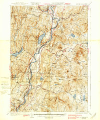
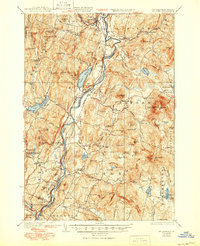
1933 Map of Mt. Cube
USGS Topo · Published 1938About this map
The Connecticut River serves as the central artery for this 1930s borderland, where the towns of Fairlee and Orford are linked by bridge and the Boston and Maine RR. The map captures a moment when the regional economy transitioned from agricultural centers like Lyme and Bradford toward the growing recreational culture of the upper valley. To the east, the Appalachian Trail winds through the hills, connecting the Dartmouth Outing Club Camp with landmarks like the Fire Tower on Smarts Mtn. The landscape is dotted with remnants of earlier rural infrastructure, including numerous district schools such as the Kidderhood Sch and Hewes Sch. While the river bottoms support settlements like North Thetford, the rugged interior hills are defined by landmarks like The Palisades and the prominent heights of Mt Cube.
Find a feature on this map
132 named features on this map. Tap any name to fly to it.
Don’t see what you’re looking for? This feature index may not catch every label — zoom into the map to look around manually.
Map Details
Editions of this 1933 Mt. Cube Map
6 editions found

Other maps of this area

1896 · Strafford
USGS Topo · 1:62,500

1906 · Hanover
USGS Topo · 1:62,500

1908 · Hanover
USGS Topo · 1:62,500

1927 · Cardigan
USGS Topo · 1:62,500

1927 · Mascoma
USGS Topo · 1:62,500

1928 · Rumney
USGS Topo · 1:62,500

1929 · Moosilauke
USGS Topo · 1:62,500

1930 · Cardigan
USGS Topo · 1:62,500

1931 · Mt. Cube
USGS Topo · 1:62,500

1931 · Woodsville
USGS Topo · 1:48,000